
Satellite data for farming
How satellite data is helping farmers overcome challenges that impact their yields
According to Agriculture and Agri-Food Canada (AAFC), there are approximately 194,000 farms in Canada concentrated in the Prairies, Quebec and Ontario. In addition to feeding us, agriculture is a major and diversified economic driver that produces annual revenues in Canada of approximately $69 billion.
How can we sustainably and responsibly maximize land yields when agricultural producers are facing numerous challenges that affect their yields? Part of the answer lies not here on Earth but in space, with data from satellites including Canadian ones: RADARSAT-1 (–), RADARSAT-2 launched in , and the RADARSAT Constellation Mission (RCM) launched in .
The role of satellites in agriculture
More than ever, Earth observation data is playing a key role in agriculture, both domestically and globally. Satellites provide a unique perspective of farmlands, e.g. thermal imagery, moisture detection, ground movement monitoring and surface changes, insect infestations, plant health, drainage network, flooding and droughts. Their strength lies in the range of data and the information that they make available.
The added value for farmers is undeniable, particularly in the context of climate change. Seasons have become highly variable from one year to the next and are causing increasingly complex problems. One need only think of the floods, droughts, early or late frosts or early snowfall in autumn. The whims of Mother Nature are enough to give farmers headaches!
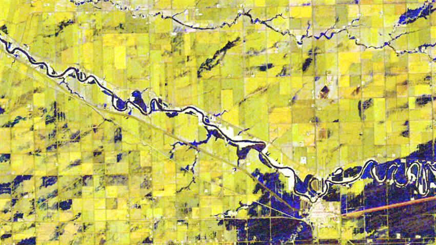
RCM satellite image of farm fields in Manitoba, several of which were affected by flooding, taken . (RADARSAT Constellation Mission imagery © Government of Canada []. RADARSAT is an official mark of the Canadian Space Agency. Data processed by Dromadaire Géo-Innovations)
The Canadian Space Agency (CSA) works with many collaborators—governments and departments, private companies and researchers—to develop applications that use satellite data for agriculture.
Crop inventories
It is in this context that AAFC uses satellite data to better understand the scope, condition and diversity of agricultural land in Canada.
The development of expertise and the use of radar data has led to new solutions and applications, which include a map presenting a Canada-wide inventory of crops, from Newfoundland to British Columbia. This online application for the general public is especially useful for Canadian agricultural co-operatives and farmers.
The Annual Crop Inventory, which maps land use and cover within Canada's agricultural extent, is created using RCM data in combination with other satellite-derived data from the United States Geological Survey and the European Space Agency.
Satellite imagery can be used to estimate the condition of crops and to determine the amount of cropland and the type of crop (e.g. wheat, barley, soybean) as well as the volume that will be produced, for example.
Farmers and agronomists in turn use these maps to assess soil and crop properties, and to inform their actions to optimize crop yields and farm sustainability.
AAFC produces maps of soil moisture to improve crop yield forecasts, monitor water runoff and flood levels, and gain a better understanding of the carbon cycle.
This information derived from satellite imagery is available to agricultural producers on their smartphones, enabling them to determine soil moisture content at a given frequency, the condition of their crops or certain areas of their fields, where fertilizer needs to be applied, and many other key pieces of information. In this way, farmers can focus workers' efforts and reduce the consumption of energy, water and inputs.
Involvement of the private sector
ClimAg – Understanding and managing vegetation, for our food and energy security
To facilitate the adoption of sustainable agricultural practices that are resilient to climate change, the Quebec-based company Effigis, a leader in geospatial information for over 30 years, developed an application for plant and crop mapping and monitoring tools with the support of the CSA.
Between and , the company produced interactive maps, available through a Web portal, for farmers, agricultural co-operatives and insurance companies. This information derived from satellite imagery was made available to agricultural producers on their smartphones, enabling farmers to determine soil moisture content on a regular basis, the condition of their crops and fields, where to apply fertilizer, and many other pieces of information critical to their operations. This information helps focus workers' efforts and reduce the consumption of energy, water and inputs. By systematically monitoring crop growth and harvests, farmers were able to assess risks related to diseases and weeds and to make the necessary adjustments where possible.
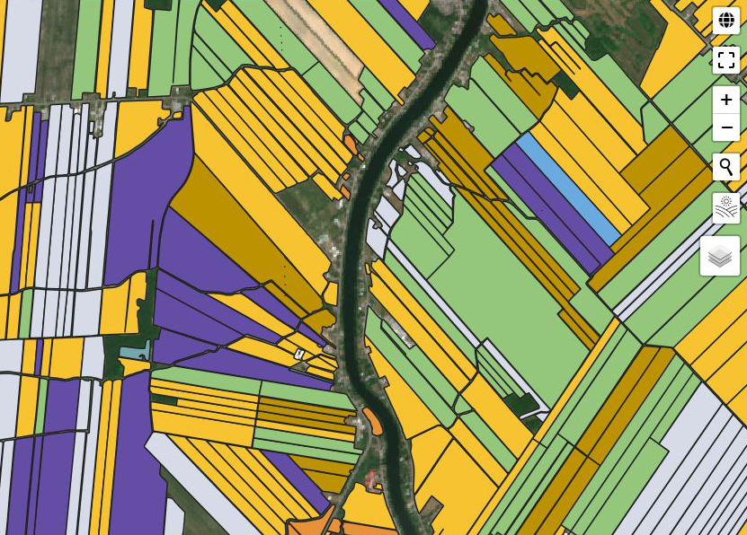
Example of the interface of the application for plant and crop mapping and monitoring tools. (Credit: Effigis)
The CSA's investments have advanced the development of a new vegetation monitoring and control solution using very high-resolution satellite and aerial images. The information extracted from these images identifies vegetation and trees that pose a risk to power distribution networks. This critical information makes it easier to plan ground responses and makes networks more resilient in the face of extreme weather events, thereby reducing the number of outages. This ensures stable power distribution and energy security, in both urban and agricultural settings.
The CSA's smartEarth initiative, launched in , supports the development of innovative solutions using satellite data to meet the diverse needs of everyday life, including in agriculture. It promotes collaboration, better expertise and increased scientific knowledge. In early , some 20 projects were selected following an Announcement of Opportunity. Contributions for these projects total approximately $8 million.
In an era where farmers are facing increasing challenges, solutions that use satellite data provide a great source of help. Satellite data has everything—frequency, parameters and accuracy—to make life easier for those who work tirelessly, day after day, to secure our food supply.